 vesseltracker.com
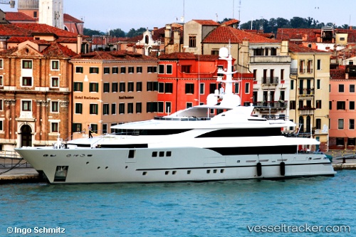
Vessel PERSEFONI I IMO: 9636515, MMSI: 229702000 Houseboat
UTC, 38.03613, 23.49926, course: 130, speed: 0
UTC, 38.03613, 23.49928, course: 130, speed: 0
2026-02-23 00:19:00 UTC, 38.03612, 23.49928, course: 130, speed: 0
Live AIS position:
UTC. Near Eleusis),
updated 2026-02-23 00:19:00 UTC.
Find the position of the vessel PERSEFONI I on the map. The latter are known coordinates and path.
marine traffic ship tracker show on live map
The current position of vessel PERSEFONI I is 38.03612 lat / 23.49928 lng. Updated: 2026-02-23 00:19:00 UTCCurrently sailing under the flag of Malta
PERSEFONI I built in 2012 year
Deadweight:
133 tDetails:
Last coordinates of the vessel:
UTC, 38.03613, 23.49927, course: 130, speed: 0UTC, 38.03613, 23.49926, course: 130, speed: 0
UTC, 38.03613, 23.49928, course: 130, speed: 0
2026-02-23 00:19:00 UTC, 38.03612, 23.49928, course: 130, speed: 0