 vesseltracker.com
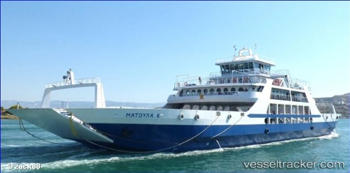
Vessel Matoula K IMO: 8647658, MMSI: 239005400 Passenger Ro Ro Cargo Ship
UTC, 37.96505, 23.52917, course: -1, speed: 0
UTC, 37.96505, 23.52917, course: -1, speed: 0
2026-02-23 12:54:09 UTC, 37.96505, 23.52917, course: -1, speed: 0
Live AIS position:
UTC. Near Paloúkia),
updated 2026-02-23 12:54:09 UTC.
Find the position of the vessel Matoula K on the map. The latter are known coordinates and path.
marine traffic ship tracker show on live map
The current position of vessel Matoula K is 37.96505 lat / 23.52917 lng. Updated: 2026-02-23 12:54:09 UTCDetails:
Last coordinates of the vessel:
UTC, 37.96523, 23.52953, course: -1, speed: 0UTC, 37.96505, 23.52917, course: -1, speed: 0
UTC, 37.96505, 23.52917, course: -1, speed: 0
2026-02-23 12:54:09 UTC, 37.96505, 23.52917, course: -1, speed: 0