 vesseltracker.com
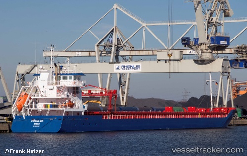
Vessel Frisian Sea IMO: 9534547, MMSI: 244780424 Multi Purpose Carrier
UTC, 51.09575, 3.74683, course: 335, speed: 0
UTC, 51.09573, 3.74684, course: 335, speed: 0
2026-03-10 07:46:22 UTC, 51.09576, 3.74686, course: 335, speed: 0
Live Vessel Frisian Sea Analytics (details, animations, etc.)
Live AIS position: UTC. Near Oostakker), updated 2026-03-10 07:46:22 UTC.Find the position of the vessel Frisian Sea on the map. The latter are known coordinates and path.
marine traffic ship tracker show on live map
The current position of vessel Frisian Sea is 51.09576 lat / 3.74686 lng. Updated: 2026-03-10 07:46:22 UTCCurrently sailing under the flag of Netherlands
Frisian Sea built in 2014 year
Deadweight:
6477 tDetails:
Last coordinates of the vessel:
UTC, 51.09577, 3.74684, course: 335, speed: 0UTC, 51.09575, 3.74683, course: 335, speed: 0
UTC, 51.09573, 3.74684, course: 335, speed: 0
2026-03-10 07:46:22 UTC, 51.09576, 3.74686, course: 335, speed: 0