 vesseltracker.com
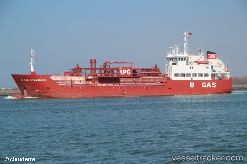
Vessel B Gas Commander IMO: 9112155, MMSI: 256792000 Lpg Tanker
UTC, 34.49333, 133.72667, course: -1, speed: 0
UTC, 34.49333, 133.72667, course: -1, speed: 0
2026-03-13 05:50:09 UTC, 34.49333, 133.72667, course: -1, speed: 0
Live Vessel B Gas Commander Analytics (details, animations, etc.)
Live AIS position: UTC. Near MIZUSHIMA), updated 2026-03-13 05:50:09 UTC.Find the position of the vessel B Gas Commander on the map. The latter are known coordinates and path.
marine traffic ship tracker show on live map
The current position of vessel B Gas Commander is 34.49333 lat / 133.72667 lng. Updated: 2026-03-13 05:50:09 UTCCurrently sailing under the flag of Malta
B Gas Commander built in 1996 year
Deadweight:
2335 tDetails:
Last coordinates of the vessel:
UTC, 34.49333, 133.72667, course: -1, speed: 0UTC, 34.49333, 133.72667, course: -1, speed: 0
UTC, 34.49333, 133.72667, course: -1, speed: 0
2026-03-13 05:50:09 UTC, 34.49333, 133.72667, course: -1, speed: 0