 vesseltracker.com
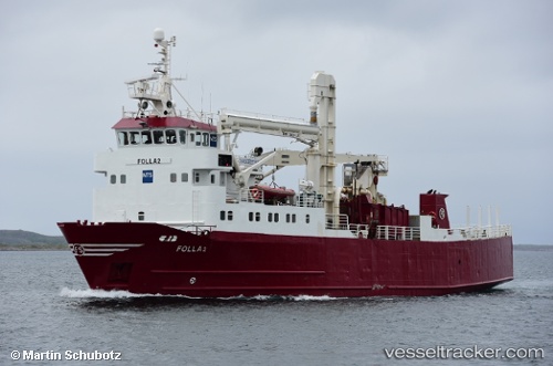
 CANASTA
Current Status
Where is the vessel?
CANASTA is currently in Near Stokkvågen, based on AIS data received about 1h ago.
Latest AIS update:
Current position: 66.33979° N, 12.95680° E (Near Stokkvågen)
Average speed (last 7 days): Loading…
Average speed (last 30 days): Loading…
Vessel profile: CANASTA is a General Cargo with dimensions m x m.
This page combines live AIS, route history, probable destination signals, nearby traffic, and port activity for practical vessel monitoring.
The current position of vessel CANASTA is 66.33979 lat / 12.95680 lng. Updated: 2026-03-25 23:44:54 UTCNearest reference points:
- Near Lurøy
- Near Vikholmen
- Near Tonnes
Currently sailing under the flag of Norway ![]()
Details:
Live Vessel CANASTA Analytics (details, animations, etc.)
Recent AIS points (UTC):
2026-03-25 18:20:23 UTC · 66.65301, 13.05145 · SOG 9.7 kn · COG 65°2026-03-25 19:34:13 UTC · 66.51178, 12.98949 · SOG 9.7 kn · COG 132°
2026-03-25 21:38:53 UTC · 66.28059, 12.91630 · SOG 8 kn · COG 187°
2026-03-25 23:44:54 UTC · 66.33979, 12.95680 · SOG 8.7 kn · COG 13°