 vesseltracker.com
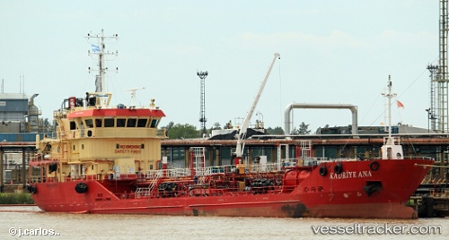
Vessel 'KADRIYE ANA' IMO: 9449235, MMSI: 271040291
UTC, 40.76168, 29.68043, course: 278, speed: 0
UTC, 40.76177, 29.68035, course: 276, speed: 0.1
2026-01-19 13:43:01 UTC, 40.76108, 29.67999, course: 329, speed: 0.4
Live AIS position:
UTC. Near Evyap),
updated 2026-01-19 13:43:01 UTC.
Find the position of the vessel 'KADRIYE ANA' on the map. The latter are known coordinates and path.
marine traffic ship tracker show on live map
The current position of vessel 'KADRIYE ANA' is 40.76108 lat / 29.67999 lng. Updated: 2026-01-19 13:43:01 UTCDetails:
Last coordinates of the vessel:
UTC, 40.76196, 29.68030, course: 232, speed: 0.1UTC, 40.76168, 29.68043, course: 278, speed: 0
UTC, 40.76177, 29.68035, course: 276, speed: 0.1
2026-01-19 13:43:01 UTC, 40.76108, 29.67999, course: 329, speed: 0.4