 vesseltracker.com
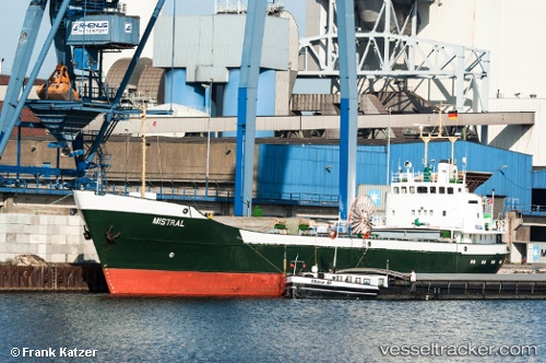
Vessel Mistral IMO: 6617855, MMSI: 304010366 Multi Purpose Carrier
UTC, 6.80400, -58.17637, course: 195, speed: 0
UTC, 6.80378, -58.17627, course: 226, speed: 0
2026-01-14 13:28:59 UTC, 6.80268, -58.17663, course: 18, speed: 0
Live AIS position:
UTC. Near Georgetown),
updated 2026-01-14 13:28:59 UTC.
Find the position of the vessel Mistral on the map. The latter are known coordinates and path.
marine traffic ship tracker show on live map
The current position of vessel Mistral is 6.80268 lat / -58.17663 lng. Updated: 2026-01-14 13:28:59 UTCCurrently sailing under the flag of Antigua Barbuda
Mistral built in 1966 year
Deadweight:
1252 tDetails:
Last coordinates of the vessel:
UTC, 6.80403, -58.17633, course: 194, speed: 0UTC, 6.80400, -58.17637, course: 195, speed: 0
UTC, 6.80378, -58.17627, course: 226, speed: 0
2026-01-14 13:28:59 UTC, 6.80268, -58.17663, course: 18, speed: 0