 vesseltracker.com
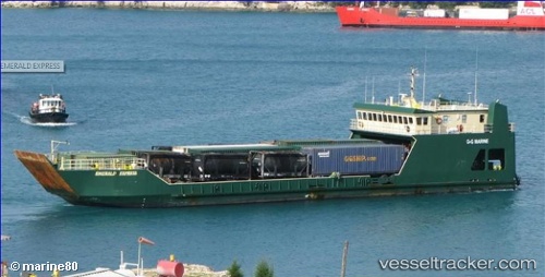
Vessel EMERALD EXPRESS IMO: 9248332, MMSI: 304840000 Landing Craft
UTC, 26.15919, -76.99431, course: 191, speed: 9.9
UTC, 25.82667, -77.14167, course: -1, speed: 9
2026-03-03 05:43:40 UTC, 25.83000, -77.49753, course: -1, speed: 10.2
Live AIS position:
UTC. 15 nm S of Gorda Cay),
updated 2026-03-03 05:43:40 UTC.
Find the position of the vessel EMERALD EXPRESS on the map. The latter are known coordinates and path.
marine traffic ship tracker show on live map
The current position of vessel EMERALD EXPRESS is 25.83000 lat / -77.49753 lng. Updated: 2026-03-03 05:43:40 UTCCurrently sailing under the flag of Antigua and Barbuda
Details:
Last coordinates of the vessel:
UTC, 26.42928, -76.92658, course: 178, speed: 7.9UTC, 26.15919, -76.99431, course: 191, speed: 9.9
UTC, 25.82667, -77.14167, course: -1, speed: 9
2026-03-03 05:43:40 UTC, 25.83000, -77.49753, course: -1, speed: 10.2