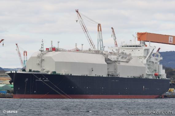
.
Vessel photo of Nohshu Maru (IMO 9796781) vesseltracker.com

BS flag Nohshu Maru

Vessel type: Lng Tanker | IMO: 9796781 | MMSI: MMSI: 311000579
Call sign: C6CU8 | Dimensions: 298 m x 298 m
Current Status

Where is the vessel?

Nohshu Maru is currently in 34 nm S of Hettimulla, based on AIS data received about 1h ago.

Latest AIS update:

Current position: 6.70167° N, 80.00333° W (34 nm S of Hettimulla)

Average speed (last 7 days): Loading…

Average speed (last 30 days): Loading…

Vessel profile: Nohshu Maru is a Lng Tanker with dimensions 298m x 298m.

This page combines live AIS, route history, probable destination signals, nearby traffic, and port activity for practical vessel monitoring.

The current position of vessel Nohshu Maru is 6.70167 lat / -80.00333 lng. Updated: 2026-03-25 07:58:11 UTC
Nearest reference points:
  • 20 nm S of El Puerto
  • 30 nm E of El Cirial (Isla Iguana)
  • Near Saboga

Currently sailing under the flag of Bahamas BS flag

Details:

Live Vessel Nohshu Maru Analytics (details, animations, etc.)


Recent AIS points (UTC):
2026-03-25 01:50:21 UTC · 8.25130, -79.46080 · SOG 16.7 kn · COG 182°
2026-03-25 04:16:09 UTC · 7.55667, -79.43500 · SOG 17 kn · COG -1°
2026-03-25 06:18:32 UTC · 7.06369, -79.70723 · SOG 17.2 kn · COG 216°
2026-03-25 07:58:11 UTC · 6.70167, -80.00333 · SOG 16 kn · COG -1°

Track of the vessel in the last 28 days


UTC: --
Start: -- Track timeline (UTC) End: --
Encountered: --


Link to the map:


Find another ship

Nohshu_Maru (311000579) last ports (portcalls and passsages)

Cameron | 2025-09-15 13:18:41
JURONG ISLAND | 2025-08-14 05:44:54
BUKOM ISLAND | 2025-08-14 04:28:29
Singapore | 2025-08-14 03:44:34
PULAU SAMBU | 2025-08-14 03:34:46
PENGERANG | 2025-08-14 02:20:05
ASHBURTON | 2025-07-26 08:26:33
ONSLOW | 2025-07-26 07:59:32
Yokkaichi | 2025-07-14 00:59:30
PENGERANG | 2025-06-27 04:01:04
TANAH MERAH | 2025-06-27 03:19:18
BUKOM ISLAND | 2025-06-26 04:13:14
JURONG ISLAND | 2025-06-26 03:08:51
Calais | 2025-04-19 13:20:07
CAMERON | 2025-04-02 01:41:36
Calais | 2025-03-16 21:12:07
ARANSAS PASS | 2025-02-27 03:24:47
PORT ARANSAS | 2025-02-25 20:54:27
Calais | 2025-02-09 09:23:22
CAMERON | 2025-01-23 20:25:03
CAMERON | 2025-01-19 09:05:06
JURONG ISLAND | 2024-12-16 05:02:30
BUKOM ISLAND | 2024-12-16 02:58:08
PULAU SAMBU | 2024-12-16 02:29:05
TANAH MERAH | 2024-12-16 01:06:34
PENGERANG | 2024-11-29 05:02:09
BATU AMPAR | 2024-11-29 03:28:43
PULAU SAMBU | 2024-11-29 02:49:49
Yokosuka | 2024-09-10 02:58:03
Yokohama | 2024-09-09 00:58:04
Kawasaki | 2024-09-09 00:14:43
Singapore | 2024-06-22 03:17:58
Yokohama | 2024-06-15 04:39:25
Kawasaki | 2024-06-15 04:17:56
Yokosuka | 2024-06-13 22:51:14
Sambu | 2024-06-05 02:15:40
Port Elizabeth | 2024-02-24 04:55:37
Calais | 2023-12-25 07:21:25
Calais | 2023-11-20 15:12:38
Strait Of Gibraltar | 2023-11-05 11:54:34
Strait Of Gibraltar | 2023-10-26 19:00:53
Singapore | 2023-09-08 14:01:05
Yokkaichi | 2023-09-01 00:21:13
Yokohama | 2023-06-20 08:13:41
Calais | 2023-04-04 07:35:14
Milford Haven | 2023-01-13 17:58:11
St. Louis Du Rhone | 2022-11-10 08:09:38
Algeciras | 2022-11-05 11:28:21
Calais | 2022-09-10 14:02:50
Freeport | 2022-08-29 16:03:38
Calais | 2022-06-26 07:28:24
Calais | 2022-06-22 04:06:05
Strait Of Gibraltar | 2022-06-16 19:35:02
Algeciras | 2022-06-16 10:46:35
Balboa | 2022-03-25 21:05:06
Cristobal | 2022-03-25 12:40:16
Calais | 2022-01-11 07:00:04
Strait Of Gibraltar | 2022-01-04 18:15:04
Algeciras | 2022-01-03 08:35:47
Strait Of Gibraltar | 2022-01-03 05:07:45