 vesseltracker.com
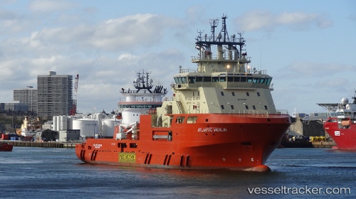
Vessel ATLANTIC MERLIN IMO: 9557458, MMSI: 316027612 Offshore Tug/Supply Ship
UTC, 47.56722, -52.70178, course: 220, speed: 0
UTC, 47.56722, -52.70178, course: 221, speed: 0
2026-01-16 17:10:49 UTC, 47.56907, -52.69333, course: 109, speed: 0
Live AIS position:
UTC. Near ST JOHNS),
updated 2026-01-16 17:10:49 UTC.
Find the position of the vessel ATLANTIC MERLIN on the map. The latter are known coordinates and path.
marine traffic ship tracker show on live map
The current position of vessel ATLANTIC MERLIN is 47.56907 lat / -52.69333 lng. Updated: 2026-01-16 17:10:49 UTCCurrently sailing under the flag of Canada
ATLANTIC MERLIN built in 2014 year
Deadweight:
4500 tDetails:
Last coordinates of the vessel:
UTC, 47.56723, -52.70178, course: 221, speed: 0.1UTC, 47.56722, -52.70178, course: 220, speed: 0
UTC, 47.56722, -52.70178, course: 221, speed: 0
2026-01-16 17:10:49 UTC, 47.56907, -52.69333, course: 109, speed: 0