 vesseltracker.com
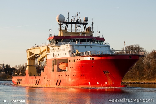
Vessel FALKOR (TOO) IMO: 9523378, MMSI: 319210400 Offshore Support Vessel
UTC, -22.89231, -43.18997, course: 110, speed: 0
UTC, -22.89232, -43.18998, course: 111, speed: 0
2026-03-02 15:38:35 UTC, -22.89228, -43.18999, course: 110, speed: 0
Live AIS position:
UTC. Near Rio De Janeiro),
updated 2026-03-02 15:38:35 UTC.
Find the position of the vessel FALKOR (TOO) on the map. The latter are known coordinates and path.
marine traffic ship tracker show on live map
The current position of vessel FALKOR (TOO) is -22.89228 lat / -43.18999 lng. Updated: 2026-03-02 15:38:35 UTCCurrently sailing under the flag of Cayman Islands
FALKOR (TOO) built in 2011 year
Deadweight:
6300 tDetails:
Last coordinates of the vessel:
UTC, -22.89167, -43.18833, course: -1, speed: 0UTC, -22.89231, -43.18997, course: 110, speed: 0
UTC, -22.89232, -43.18998, course: 111, speed: 0
2026-03-02 15:38:35 UTC, -22.89228, -43.18999, course: 110, speed: 0