 vesseltracker.com
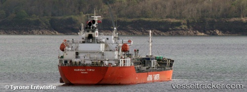
Vessel Wawasan Topaz IMO: 9565601, MMSI: 353840000 Chemical Oil Products Tanker
UTC, 23.03391, 70.22301, course: -1, speed: 0
UTC, 23.03392, 70.22301, course: -1, speed: 0
2026-03-24 03:14:17 UTC, 23.03392, 70.22301, course: -1, speed: 0
Live Vessel Wawasan Topaz Analytics (details, animations, etc.)
Live AIS position: UTC. Near Kandla), updated 2026-03-24 03:14:17 UTC.Find the position of the vessel Wawasan Topaz on the map. The latter are known coordinates and path.
marine traffic ship tracker show on live map
The current position of vessel Wawasan Topaz is 23.03392 lat / 70.22301 lng. Updated: 2026-03-24 03:14:17 UTCCurrently sailing under the flag of Panama
Wawasan Topaz built in 2010 year
Deadweight:
19854 tDetails:
Last coordinates of the vessel:
UTC, 23.03392, 70.22301, course: -1, speed: 0UTC, 23.03391, 70.22301, course: -1, speed: 0
UTC, 23.03392, 70.22301, course: -1, speed: 0
2026-03-24 03:14:17 UTC, 23.03392, 70.22301, course: -1, speed: 0