 vesseltracker.com
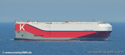
Vessel Polaris Highway IMO: 9728095, MMSI: 356874000 Vehicles Carrier
UTC, -29.86285, 31.03181, course: 315, speed: 0
UTC, -29.86287, 31.03180, course: 315, speed: 0
2026-02-09 21:55:31 UTC, -29.86288, 31.03185, course: 315, speed: 0
Live AIS position:
UTC. Near Durban),
updated 2026-02-09 21:55:31 UTC.
Find the position of the vessel Polaris Highway on the map. The latter are known coordinates and path.
marine traffic ship tracker show on live map
The current position of vessel Polaris Highway is -29.86288 lat / 31.03185 lng. Updated: 2026-02-09 21:55:31 UTCCurrently sailing under the flag of Panama
Details:
Last coordinates of the vessel:
UTC, -29.86284, 31.03182, course: 315, speed: 0UTC, -29.86285, 31.03181, course: 315, speed: 0
UTC, -29.86287, 31.03180, course: 315, speed: 0
2026-02-09 21:55:31 UTC, -29.86288, 31.03185, course: 315, speed: 0