 vesseltracker.com
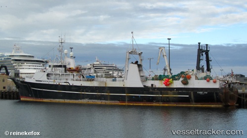
Vessel Katie Ann IMO: 6931055, MMSI: 366499000 Fish Factory Ship
UTC, 47.66113, -122.38004, course: 298, speed: 0
UTC, 47.66113, -122.38004, course: 298, speed: 0
2026-03-16 22:58:42 UTC, 47.66113, -122.38004, course: 298, speed: 0
Live Vessel Katie Ann Analytics (details, animations, etc.)
Live AIS position: UTC. Near Ballard/Seattle), updated 2026-03-16 22:58:42 UTC.Find the position of the vessel Katie Ann on the map. The latter are known coordinates and path.
marine traffic ship tracker show on live map
The current position of vessel Katie Ann is 47.66113 lat / -122.38004 lng. Updated: 2026-03-16 22:58:42 UTCCurrently sailing under the flag of USA
Katie Ann built in 1969 year
Deadweight:
1719 tDetails:
Last coordinates of the vessel:
UTC, 47.66110, -122.38011, course: 288, speed: 0.1UTC, 47.66113, -122.38004, course: 298, speed: 0
UTC, 47.66113, -122.38004, course: 298, speed: 0
2026-03-16 22:58:42 UTC, 47.66113, -122.38004, course: 298, speed: 0