 vesseltracker.com
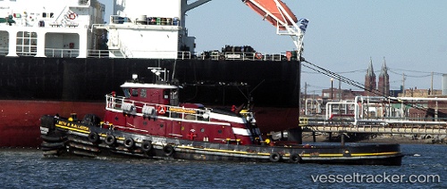
Vessel Beth M Mcallister IMO: 8980919, MMSI: 366995010 Tug
UTC, 18.44771, -66.09079, course: -1, speed: 0
UTC, 18.44771, -66.09081, course: -1, speed: 0
2026-03-24 14:00:32 UTC, 18.44770, -66.09082, course: -1, speed: 0
Live Vessel Beth M Mcallister Analytics (details, animations, etc.)
Live AIS position: UTC. Near Puerta de Tierra), updated 2026-03-24 14:00:32 UTC.Find the position of the vessel Beth M Mcallister on the map. The latter are known coordinates and path.
marine traffic ship tracker show on live map
The current position of vessel Beth M Mcallister is 18.44770 lat / -66.09082 lng. Updated: 2026-03-24 14:00:32 UTCCurrently sailing under the flag of USA
Beth M Mcallister built in 1970 year
Deadweight:
345 tDetails:
Last coordinates of the vessel:
UTC, 18.44770, -66.09080, course: -1, speed: 0UTC, 18.44771, -66.09079, course: -1, speed: 0
UTC, 18.44771, -66.09081, course: -1, speed: 0
2026-03-24 14:00:32 UTC, 18.44770, -66.09082, course: -1, speed: 0