 vesseltracker.com
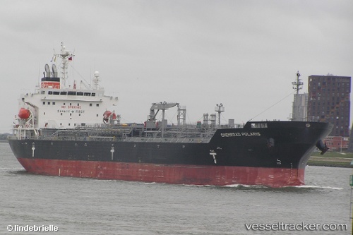
Vessel CHEMROAD POLARIS IMO: 9536923, MMSI: 370497000 Chemical/Oil Products Tanker
UTC, 37.83797, -0.27986, course: 35, speed: 13
UTC, 38.26016, 0.07962, course: 37, speed: 13.4
2026-02-21 19:47:56 UTC, 38.51089, 0.30443, course: 34, speed: 14
Live AIS position:
UTC. 13 nm SE of Moraira),
updated 2026-02-21 19:47:56 UTC.
Find the position of the vessel CHEMROAD POLARIS on the map. The latter are known coordinates and path.
marine traffic ship tracker show on live map
The current position of vessel CHEMROAD POLARIS is 38.51089 lat / 0.30443 lng. Updated: 2026-02-21 19:47:56 UTCCurrently sailing under the flag of Panama
CHEMROAD POLARIS built in 2014 year
Deadweight:
35923 tDetails:
Last coordinates of the vessel:
UTC, 37.39803, -0.74049, course: 49, speed: 12.9UTC, 37.83797, -0.27986, course: 35, speed: 13
UTC, 38.26016, 0.07962, course: 37, speed: 13.4
2026-02-21 19:47:56 UTC, 38.51089, 0.30443, course: 34, speed: 14