 vesseltracker.com
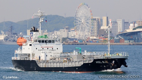
Vessel Angel Blue IMO: 9711585, MMSI: 373395000 Bitumen Tanker
UTC, 33.62425, 130.32710, course: 52, speed: 0.1
UTC, 33.62506, 130.32841, course: 231, speed: 0
2026-03-14 18:03:27 UTC, 33.62496, 130.32854, course: 239, speed: 0
Live Vessel Angel Blue Analytics (details, animations, etc.)
Live AIS position: UTC. Near Hakata), updated 2026-03-14 18:03:27 UTC.Find the position of the vessel Angel Blue on the map. The latter are known coordinates and path.
marine traffic ship tracker show on live map
The current position of vessel Angel Blue is 33.62496 lat / 130.32854 lng. Updated: 2026-03-14 18:03:27 UTCCurrently sailing under the flag of Panama
Details:
Last coordinates of the vessel:
UTC, 33.62433, 130.32704, course: 59, speed: 0UTC, 33.62425, 130.32710, course: 52, speed: 0.1
UTC, 33.62506, 130.32841, course: 231, speed: 0
2026-03-14 18:03:27 UTC, 33.62496, 130.32854, course: 239, speed: 0