 vesseltracker.com
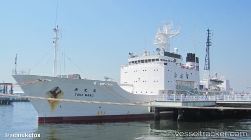
Vessel Toko Maru IMO: 9138484, MMSI: 431856000 Fishing Support Vessel
UTC, 31.59665, 130.56754, course: 177, speed: 0
UTC, 31.59668, 130.56754, course: 177, speed: 0
2026-02-02 19:16:30 UTC, 31.59666, 130.56754, course: 177, speed: 0
Live AIS position:
UTC. Near Kagoshima),
updated 2026-02-02 19:16:30 UTC.
Find the position of the vessel Toko Maru on the map. The latter are known coordinates and path.
marine traffic ship tracker show on live map
The current position of vessel Toko Maru is 31.59666 lat / 130.56754 lng. Updated: 2026-02-02 19:16:30 UTCDetails:
Last coordinates of the vessel:
UTC, 31.59667, 130.56752, course: 177, speed: 0UTC, 31.59665, 130.56754, course: 177, speed: 0
UTC, 31.59668, 130.56754, course: 177, speed: 0
2026-02-02 19:16:30 UTC, 31.59666, 130.56754, course: 177, speed: 0