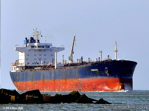
vessel I NF LIGHT IMO: 9274094, Crude Oil Tanker vesseltracker.com
Vessel I NF LIGHT IMO: 9274094, Crude Oil Tanker
MMSI: 477979100 callsign: VRWE5 size: 228x32

Find the position of the vessel I NF LIGHT on the map. The latter are known coordinates and path.

marine traffic ship tracker show on live map

The current position of vessel I NF LIGHT is 1.29634 lat / 104.127 lng. Updated: 2024-11-23 23:31:30 UTC

Currently sailing under the flag of Hong Kong

I NF LIGHT built in 2006 year

Deadweight:
72768 t

Payload_mass:
72768 tonne
Gross tonnage:
41583
Service entry:
2006-01-01T00:00:00Z

Manufacturer:
Dalian Shipbuilding Industry Company (part of China Shipbuilding Industry Corporation)

Details:


Last coordinates of the vessel:
UTC, 1.26279, 104.134, course: 64, speed: 5.8
UTC, 1.29627, 104.127, course: 70, speed: 0.1
UTC, 1.29635, 104.127, course: 72, speed: 0.1
2024-11-23 23:31:30 UTC, 1.29634, 104.127, course: 78, speed: 0

Track of the vessel in the last 14 days


Most frequent ports a vessels calls at I NF LIGHT (477979100):

Vlaardingen, traffic: 4
Maassluis, traffic: 4
Singapore, traffic: 3
Sambu, traffic: 2
PENGERANG, traffic: 2
BUKOM ISLAND, traffic: 2
TANAH MERAH, traffic: 1
Johor, traffic: 1
JURONG ISLAND, traffic: 1
SEMBAWANG, traffic: 1
PASIR GUDANG, traffic: 1
TEKONG ISLAND, traffic: 1

Link to the map:


Find another ship

I_NF_LIGHT (477979100) last ports (portcalls and passsages)

Sambu | 2024-11-23 11:04:11
Singapore | 2024-11-23 07:08:30
PENGERANG | 2024-11-23 04:29:41
PENGERANG | 2024-11-16 02:39:53
SEMBAWANG | 2024-11-14 20:51:17
Johor | 2024-11-14 19:23:00
TANAH MERAH | 2024-11-13 12:32:12
JURONG ISLAND | 2024-11-12 02:54:01
BUKOM ISLAND | 2024-11-11 21:13:38
BUKOM ISLAND | 2024-11-07 19:14:39
Sambu | 2024-11-02 16:54:17
Vlaardingen | 2023-01-16 14:55:33
Maassluis | 2023-01-12 14:43:20
Vlaardingen | 2023-01-08 14:15:27
Vlaardingen | 2023-01-04 11:29:02