 vesseltracker.com
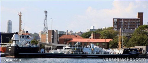
Vessel Manning IMO: 9654749, MMSI: 503000080 Oil Products Tanker
UTC, -33.85998, 151.22655, course: 237, speed: 1.9
UTC, -33.86826, 151.22205, course: -1, speed: 0
2026-03-02 00:24:57 UTC, -33.86826, 151.22205, course: -1, speed: 0
Live AIS position:
UTC. Near Woolloomooloo),
updated 2026-03-02 00:24:57 UTC.
Find the position of the vessel Manning on the map. The latter are known coordinates and path.
marine traffic ship tracker show on live map
The current position of vessel Manning is -33.86826 lat / 151.22205 lng. Updated: 2026-03-02 00:24:57 UTCDetails:
Last coordinates of the vessel:
UTC, -33.85839, 151.22778, course: 200, speed: 0UTC, -33.85998, 151.22655, course: 237, speed: 1.9
UTC, -33.86826, 151.22205, course: -1, speed: 0
2026-03-02 00:24:57 UTC, -33.86826, 151.22205, course: -1, speed: 0