 vesseltracker.com
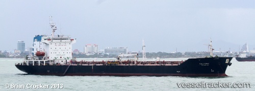
Vessel Palu Sipat IMO: 9106651, MMSI: 525004010 Crude Oil Tanker
UTC, -3.16858, 116.38130, course: 335, speed: 0
UTC, -3.16861, 116.38117, course: 340, speed: 0
2026-01-15 02:18:12 UTC, -3.16860, 116.38090, course: 354, speed: 0
Live AIS position:
UTC. Near TANJUNG PEMANCINGAN),
updated 2026-01-15 02:18:12 UTC.
Find the position of the vessel Palu Sipat on the map. The latter are known coordinates and path.
marine traffic ship tracker show on live map
The current position of vessel Palu Sipat is -3.16860 lat / 116.38090 lng. Updated: 2026-01-15 02:18:12 UTCDetails:
Last coordinates of the vessel:
UTC, -3.16848, 116.38141, course: 330, speed: 0UTC, -3.16858, 116.38130, course: 335, speed: 0
UTC, -3.16861, 116.38117, course: 340, speed: 0
2026-01-15 02:18:12 UTC, -3.16860, 116.38090, course: 354, speed: 0