 vesseltracker.com
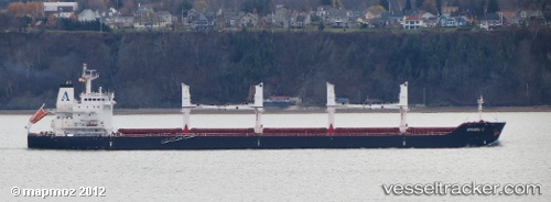
Vessel Amanda C IMO: 9482782, MMSI: 538003693 Bulk Carrier
UTC, 28.07333, -15.39500, course: -1, speed: 0
UTC, 28.08273, -15.39248, course: 31, speed: 2.2
2026-03-10 07:41:09 UTC, 28.13943, -15.41310, course: 137, speed: 1.5
Live Vessel Amanda C Analytics (details, animations, etc.)
Live AIS position: UTC. Near Las Palmas), updated 2026-03-10 07:41:09 UTC.Find the position of the vessel Amanda C on the map. The latter are known coordinates and path.
marine traffic ship tracker show on live map
The current position of vessel Amanda C is 28.13943 lat / -15.41310 lng. Updated: 2026-03-10 07:41:09 UTCCurrently sailing under the flag of Marshall Is
Amanda C built in 2012 year
Deadweight:
34449 tDetails:
Last coordinates of the vessel:
UTC, 28.07480, -15.39673, course: 35, speed: 0.4UTC, 28.07333, -15.39500, course: -1, speed: 0
UTC, 28.08273, -15.39248, course: 31, speed: 2.2
2026-03-10 07:41:09 UTC, 28.13943, -15.41310, course: 137, speed: 1.5