.
vessel Golar Frost IMO: 9655042, Lng Tanker
vesseltracker.com
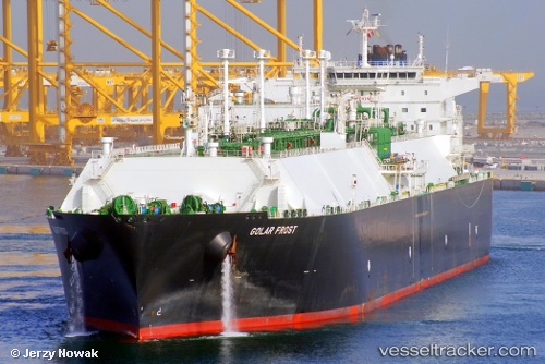
Vessel Golar Frost IMO: 9655042, MMSI: 538004975 Lng Tanker

callsign: V7AE2
size: 42x280

Live AIS position: UTC. Near SABINE PASS), updated 2026-01-29 14:15:38 UTC.

Find the position of the vessel Golar Frost on the map. The latter are known coordinates and path.

marine traffic ship tracker show on live map

The current position of vessel Golar Frost is 29.74148 lat / -93.86766 lng. Updated: 2026-01-29 14:15:38 UTC
Details:


Last coordinates of the vessel:
UTC, 29.74146, -93.86766, course: 212, speed: 0
UTC, 29.74148, -93.86768, course: 212, speed: 0
UTC, 29.74148, -93.86769, course: 212, speed: 0
2026-01-29 14:15:38 UTC, 29.74148, -93.86766, course: 212, speed: 0

Track of the vessel in the last 28 days


Most frequent ports a vessels calls at Golar Frost (538004975):

Sambu, traffic: 8
Singapore, traffic: 7
Shekou, traffic: 5
Da Chan Bay, traffic: 5
BATU AMPAR, traffic: 4
PENGERANG, traffic: 4
TANAH MERAH, traffic: 4
Balboa, traffic: 4
Panama, traffic: 4
Map Ta Phut, traffic: 4
Subic Bay, traffic: 3
PULAU SAMBU, traffic: 3
Higashi-Iwase, traffic: 3
Yokkaichi, traffic: 2
Port Louis, traffic: 2

Link to the map:


Find another ship

Golar_Frost (538004975) last ports (portcalls and passsages)

TANAH MERAH | 2025-08-30 04:38:07
BATU AMPAR | 2025-08-30 03:45:07
PULAU SAMBU | 2025-08-30 03:08:04
Rio Haina | 2025-07-24 14:49:49
BUKOM ISLAND | 2025-06-10 08:44:50
TANAH MERAH | 2025-06-10 07:52:26
PENGERANG | 2025-06-10 06:56:22
XIANTOULING | 2025-06-05 02:24:20
PENGERANG | 2025-05-26 06:54:06
TANAH MERAH | 2025-05-26 04:33:25
BATU AMPAR | 2025-05-26 04:09:57
RAS LAFFAN | 2025-05-14 04:10:54
Galle | 2025-05-01 04:00:51
JURONG ISLAND | 2025-04-13 03:02:53
TANAH MERAH | 2025-04-13 00:55:50
PENGERANG | 2025-04-12 23:48:57
DAECHEONHANG | 2025-02-24 04:26:50
BINTULU | 2025-02-10 00:24:45
BINTULU | 2025-01-21 02:57:10
PENGERANG | 2024-12-24 04:28:25
Singapore | 2024-12-24 01:41:51
PULAU SAMBU | 2024-12-24 01:18:23
POINT FORTIN | 2024-11-24 07:09:02
HOEK VAN HOLLAND | 2024-11-04 19:24:13
MAASVLAKTE - ROTTERDAM | 2024-11-04 18:43:48
Map Ta Phut | 2024-09-05 22:50:13
Gladstone Harbor | 2024-08-16 00:36:14
Da Chan Bay | 2024-07-15 05:36:39
Da Chan Bay | 2024-07-11 05:31:00
Da Chan Bay | 2024-07-07 05:26:11
Da Chan Bay | 2024-07-03 04:51:10
Da Chan Bay | 2024-06-26 07:26:38
Shekou | 2024-06-26 05:47:52
Selat Lombok | 2024-05-27 12:35:55
Batangas | 2024-05-20 00:32:56
Singapore | 2024-05-10 22:11:18
Gladstone Harbor | 2024-04-09 03:20:22
Map Ta Phut | 2024-03-12 23:47:46
St. Georges | 2024-02-12 08:55:30
Singapore | 2023-12-20 22:08:01
Map Ta Phut | 2023-12-17 07:19:51
Port Louis | 2023-10-07 00:34:33
Singapore | 2023-09-28 13:21:33
Higashi-Iwase | 2023-09-20 03:43:04
Kobe | 2023-09-19 05:13:00
Selat Lombok | 2023-07-27 03:06:50
Map Ta Phut | 2023-07-18 23:36:46
Singapore | 2023-07-05 05:41:28
Sambu | 2023-07-05 05:24:54
Algeciras | 2023-04-27 23:14:42
Strait Of Gibraltar | 2023-04-27 03:44:48
Calais | 2023-02-18 08:08:17
Port Louis | 2023-01-12 11:55:12
Oita | 2022-08-12 01:30:45
Singapore | 2022-06-29 04:47:50
Yosu | 2022-06-21 22:58:28
Yokosuka | 2022-06-10 04:26:31
Yokohama | 2022-06-09 01:32:11
Subic Bay | 2022-04-10 07:15:11
Subic Bay | 2022-04-10 00:18:09
Yokkaichi | 2022-02-21 03:35:04
Higashi-Iwase | 2022-01-24 04:50:03
Panama | 2021-12-29 23:55:20
Panama | 2021-12-29 23:40:20
Balboa | 2021-12-29 19:40:09
Cristobal | 2021-12-28 13:00:02