vessel Baosteel Expedition IMO: 9346184, Ore Carrier
vesseltracker.com
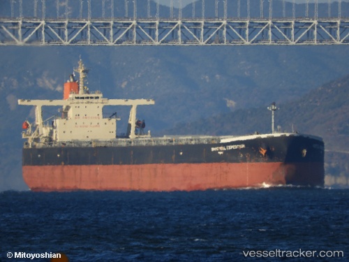
Vessel Baosteel Expedition IMO: 9346184, Ore Carrier
MMSI: 636013163 callsign: A8LB7 size: 50x300

Find the position of the vessel Baosteel Expedition on the map. The latter are known coordinates and path.

marine traffic ship tracker show on live map

The current position of vessel Baosteel Expedition is 21.5574 lat / 108.354 lng. Updated: 2025-07-18 08:11:39 UTC
Details:


Last coordinates of the vessel:
UTC, 21.5573, 108.354, course: 16, speed: 0
UTC, 21.5573, 108.354, course: 17, speed: 0
2025-07-18 08:11:39 UTC, 21.5574, 108.354, course: 17, speed: 0

Track of the vessel in the last 14 days


Most frequent ports a vessels calls at Baosteel Expedition (636013163):

Sambu, traffic: 6
Qingdao, traffic: 5
Singapore, traffic: 5
Fangcheng, traffic: 3
PENGERANG, traffic: 2
BATU AMPAR, traffic: 2
TANAH MERAH, traffic: 2
Yosu, traffic: 2
Port Headland, traffic: 2
Port Hedland, traffic: 2
JURONG ISLAND, traffic: 1
PULAU SAMBU, traffic: 1
Selat Sunda, traffic: 1
Tokuyama, traffic: 1
Yeosu, traffic: 1

Link to the map:


Find another ship

Baosteel_Expedition (636013163) last ports (portcalls and passsages)

Fangcheng | 2025-07-14 14:12:17
PENGERANG | 2025-07-03 22:17:33
TANAH MERAH | 2025-07-03 08:07:08
PULAU SAMBU | 2025-07-03 06:18:06
JURONG ISLAND | 2024-12-08 22:43:47
BATU AMPAR | 2024-12-08 20:39:57
TANAH MERAH | 2024-12-08 02:40:06
PENGERANG | 2024-12-07 23:45:05
Selat Sunda | 2024-07-15 12:02:52
Singapore | 2024-04-29 01:25:05
Fangcheng | 2024-04-21 17:05:15
Fangcheng | 2024-04-17 16:10:05
Sambu | 2024-01-21 07:34:03
Qingdao | 2024-01-10 21:13:55
Qingdao | 2024-01-02 23:58:03
Port Elizabeth | 2023-11-27 01:51:55
Singapore | 2023-09-30 02:23:10
Qingdao | 2023-09-20 02:21:59
Qingdao | 2023-09-15 02:25:30
Sambu | 2023-05-19 20:21:38
Qingdao | 2023-05-07 09:42:22
Sambu | 2022-10-30 11:32:25
Tokuyama | 2022-02-21 04:15:18
Port Headland | 2021-12-30 06:40:09
Yosu | 2021-12-08 15:39:15