 vesseltracker.com
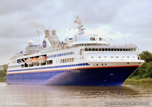
Vessel BLUE DREAM STAR IMO: 9183518, MMSI: 636020005 Passenger (Cruise) Ship
UTC, 31.41433, 121.49900, course: -1, speed: 0.1
UTC, 31.41429, 121.49897, course: -1, speed: 0.1
2026-03-04 03:20:23 UTC, 31.41429, 121.49897, course: -1, speed: 0
Live AIS position:
UTC. Near Baoshan Pt),
updated 2026-03-04 03:20:23 UTC.
Find the position of the vessel BLUE DREAM STAR on the map. The latter are known coordinates and path.
marine traffic ship tracker show on live map
The current position of vessel BLUE DREAM STAR is 31.41429 lat / 121.49897 lng. Updated: 2026-03-04 03:20:23 UTCCurrently sailing under the flag of Liberia
BLUE DREAM STAR built in 2001 year
Deadweight:
2490 tDetails:
Last coordinates of the vessel:
UTC, 31.41429, 121.49898, course: -1, speed: 0.1UTC, 31.41433, 121.49900, course: -1, speed: 0.1
UTC, 31.41429, 121.49897, course: -1, speed: 0.1
2026-03-04 03:20:23 UTC, 31.41429, 121.49897, course: -1, speed: 0