 vesseltracker.com
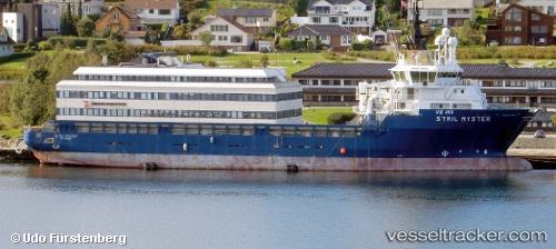
Vessel OCEAN KARADENIZ IMO: 9243370, MMSI: 636020319 Offshore Supply Ship
UTC, 40.84297, 14.26265, course: 330, speed: 0
UTC, 40.76214, 14.22593, course: 210, speed: 9.8
2026-01-30 10:23:09 UTC, 40.55679, 13.81650, course: 242, speed: 10.7
Live AIS position:
UTC. 11 nm S of Forio),
updated 2026-01-30 10:23:09 UTC.
Find the position of the vessel OCEAN KARADENIZ on the map. The latter are known coordinates and path.
marine traffic ship tracker show on live map
The current position of vessel OCEAN KARADENIZ is 40.55679 lat / 13.81650 lng. Updated: 2026-01-30 10:23:09 UTCCurrently sailing under the flag of Liberia
OCEAN KARADENIZ built in 2003 year
Deadweight:
4500 tDetails:
Last coordinates of the vessel:
UTC, 40.84298, 14.26264, course: 329, speed: 0UTC, 40.84297, 14.26265, course: 330, speed: 0
UTC, 40.76214, 14.22593, course: 210, speed: 9.8
2026-01-30 10:23:09 UTC, 40.55679, 13.81650, course: 242, speed: 10.7