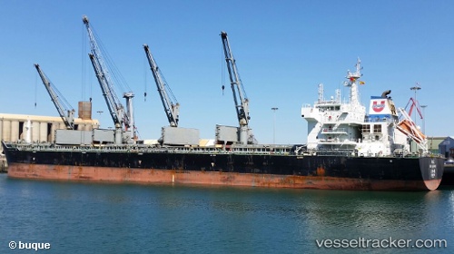
vessel PROTECTOR ST. JOHN IMO: 9474656, Bulk Carrier vesseltracker.com
Vessel PROTECTOR ST. JOHN IMO: 9474656, Bulk Carrier
MMSI: 636021891 callsign: 5LGE7 size: x

Find the position of the vessel PROTECTOR ST. JOHN on the map. The latter are known coordinates and path.

marine traffic ship tracker show on live map

The current position of vessel PROTECTOR ST. JOHN is 6.33078 lat / 79.2484 lng. Updated: 2024-07-27 03:27:51 UTC

Currently sailing under the flag of Liberia

PROTECTOR ST. JOHN built in 2012 year

Port of registry:
Singapore (sovereign island country and city-state in maritime Southeast Asia)
Deadweight:
56562 t

Payload_mass:
56562 tonne
Gross tonnage:
33035
Service entry:
2012-01-01T00:00:00Z
Details:


Last coordinates of the vessel:
UTC, 6.17201, 79.5663, course: 306, speed: 10.3
UTC, 6.23518, 79.4481, course: 302, speed: 10.3
UTC, 6.31235, 79.2842, course: 301, speed: 10.3
2024-07-27 03:27:51 UTC, 6.33078, 79.2484, course: 302, speed: 10.3

Track of the vessel in the last 14 days


Most frequent ports a vessels calls at PROTECTOR ST. JOHN (636021891):

Safi, traffic: 5
Umm Said, traffic: 2
Halul Island, traffic: 2
Mina Saqr, traffic: 2
Strait Of Gibraltar, traffic: 1
Bur Ibrahim, traffic: 1
Chittagong, traffic: 1
Fujairah, traffic: 1
Kandla, traffic: 1
Navlakhi, traffic: 1
Singapore, traffic: 1

Link to the map:


Find another ship

PROTECTOR_ST._JOHN (636021891) last ports (portcalls and passsages)

Kandla | 2023-12-21 17:23:22
Mina Saqr | 2023-12-09 15:36:31
Navlakhi | 2023-01-02 08:21:59
Chittagong | 2022-12-02 14:04:22
Fujairah | 2022-11-19 17:17:58
Mina Saqr | 2022-11-18 08:16:35
Halul Island | 2022-11-15 14:16:27
Umm Said | 2022-11-13 23:59:11
Umm Said | 2022-11-09 20:33:11
Halul Island | 2022-11-09 12:07:54
Safi | 2022-09-14 04:55:46
Safi | 2022-09-10 01:16:39
Safi | 2022-09-05 22:55:31
Safi | 2022-09-01 22:40:14
Safi | 2022-08-28 19:39:17
Strait Of Gibraltar | 2022-08-27 19:34:17
Bur Ibrahim | 2022-08-18 16:58:14
Singapore | 2022-06-14 07:08:52