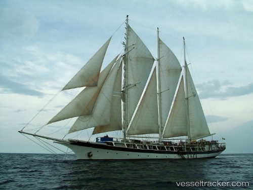
vessel Mandalay IMO: 7738383, Cruise Ship
Vessel Mandalay IMO: 7738383, Cruise Ship
MMSI: 677057200 callsign: 5IM672 size: 10x70

Find the position of the vessel Mandalay on the map. The latter are known coordinates and path.

marine traffic ship tracker show on live map

The current position of vessel Mandalay is 1.11529 lat / 103.899 lng. Updated: 2025-05-07 15:36:26 UTC
Gross tonnage:
420
Operator:
Lamont–Doherty Earth Observatory (scientific observatory in the United States)
Service entry:
1923-01-01T00:00:00Z

Manufacturer:
Burmeister & Wain (company)


Owned:
Windjammer Barefoot Cruises (American leisure cruise line)
Details:


Last coordinates of the vessel:
2025-05-07 15:36:26 UTC, 1.11529, 103.899, course: -1, speed: 0

Track of the vessel in the last 14 days


Most frequent ports a vessels calls at Mandalay (677057200):

Sambu, traffic: 6
PULAU SAMBU, traffic: 6
BATU AMPAR, traffic: 5
Cape St. Jacques, traffic: 4
Vung Tau, traffic: 4
Gemalink, traffic: 4
Cai Mep, traffic: 4
PENGERANG, traffic: 3

Link to the map:


Find another ship

Mandalay (677057200) last ports (portcalls and passsages)

PULAU SAMBU | 2025-05-07 08:40:05
BATU AMPAR | 2025-05-07 07:43:16
Cai Mep | 2025-04-17 22:46:03
Gemalink | 2025-04-17 21:55:12
Cape St. Jacques | 2025-04-17 20:02:37
Cai Mep | 2025-03-26 22:47:43
Cape St. Jacques | 2025-03-26 20:19:54
PENGERANG | 2025-03-21 18:50:57
PULAU SAMBU | 2025-03-21 09:27:19
BATU AMPAR | 2025-03-21 07:57:26
PULAU SAMBU | 2025-03-03 02:20:51
PULAU SAMBU | 2025-02-27 01:53:55
BATU AMPAR | 2025-02-27 01:14:13
PENGERANG | 2025-02-26 22:06:11
Cai Mep | 2025-02-18 06:06:14
Cape St. Jacques | 2025-02-18 04:33:05
Cai Mep | 2025-01-22 08:26:24
Cape St. Jacques | 2025-01-22 05:19:21
PENGERANG | 2025-01-08 12:48:51
BATU AMPAR | 2025-01-08 09:53:46
PULAU SAMBU | 2025-01-08 08:39:17
BATU AMPAR | 2024-12-10 11:16:45