 vesseltracker.com
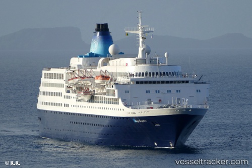
 BLUE SAPPHIRE
Current Status
Where is the vessel?
BLUE SAPPHIRE is currently in Near CESME, based on AIS data received about 1h ago.
Latest AIS update:
Current position: 38.32496° N, 26.25193° E (Near CESME)
Average speed (last 7 days): Loading…
Average speed (last 30 days): Loading…
Vessel profile: BLUE SAPPHIRE is a Passengers Ship with dimensions m x m.
This page combines live AIS, route history, probable destination signals, nearby traffic, and port activity for practical vessel monitoring.
The current position of vessel BLUE SAPPHIRE is 38.32496 lat / 26.25193 lng. Updated: 2026-03-25 15:41:53 UTCNearest reference points:
- Near CESME
- 13 nm NW of Karkinagri Ikarias
- Near FOURNI
Currently sailing under the flag of Saint Kitts and Nevis ![]()
Details:
Live Vessel BLUE SAPPHIRE Analytics (details, animations, etc.)
Recent AIS points (UTC):
2026-03-25 09:55:57 UTC · 38.31650, 26.24772 · SOG 0.3 kn · COG 11°2026-03-25 12:22:57 UTC · 38.31449, 26.24675 · SOG 0.9 kn · COG 358°
2026-03-25 13:46:57 UTC · 38.31273, 26.24731 · SOG 1.5 kn · COG 314°
2026-03-25 15:41:53 UTC · 38.32496, 26.25193 · SOG 0.3 kn · COG 16°