vessel ORIENTAL LINKS IMO: 9205653, Chemical/Oil Products Tanker vesseltracker.com
Vessel ORIENTAL LINKS IMO: 9205653, Chemical/Oil Products Tanker
MMSI: 341471000 callsign: V4RL4 size: 18x114

Find the position of the vessel ORIENTAL LINKS on the map. The latter are known coordinates and path.

marine traffic ship tracker show on live map

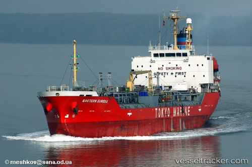
The current position of vessel ORIENTAL LINKS is 29.5552 lat / 48.9046 lng. Updated: 2024-04-21 15:02:50 UTC

Currently sailing under the flag of St.Kitts and Nevis

ORIENTAL LINKS built in 1999 year

Deadweight:
8762 t

Details:


Last coordinates of the vessel:
UTC, 29.5552, 48.9046, course: -1, speed: 11.5
2024-04-21 15:02:50 UTC, 29.5552, 48.9046, course: -1, speed: 11.5


Most frequent ports a vessels calls at ORIENTAL LINKS (341471000):

Vung Tau, traffic: 8
Cape St. Jacques, traffic: 8
Gemalink, traffic: 6
Sharjah, traffic: 3
Berbera, traffic: 3
Mogadishu, traffic: 3
Sriracha, traffic: 2
Tanjung Perak, traffic: 2
Ulsan, traffic: 2
Batangas, traffic: 2
Hamriyah, traffic: 2
Port Kelang, traffic: 2
Port Swettenham, traffic: 2
Fujairah, traffic: 1

Link to the map:


Find another ship

ORIENTAL_LINKS (341471000) last ports (portcalls and passsages)

Berbera | 2023-08-10 12:55:53
Berbera | 2023-08-06 12:45:00
Berbera | 2023-08-02 12:34:28
Hamriyah | 2023-07-15 18:44:19
Hamriyah | 2023-07-11 18:09:03
Sharjah | 2023-03-26 10:32:01
Mogadishu | 2023-02-19 18:23:04
Mogadishu | 2023-02-15 17:11:51
Mogadishu | 2023-02-11 14:47:57
Fujairah | 2022-03-09 15:12:07
Sharjah | 2022-02-09 06:30:48
Port Swettenham | 2022-01-26 07:17:40
Sriracha | 2022-01-20 10:31:35
Tanjung Perak | 2022-01-12 21:20:01
Vung Tau | 2022-01-03 07:50:20
Gemalink | 2022-01-03 07:47:05
Gemalink | 2022-01-02 02:20:04
Gemalink | 2022-01-02 02:00:04
Cape St. Jacques | 2022-01-02 01:55:07
Cape St. Jacques | 2022-01-02 00:45:01
Batangas | 2021-12-25 08:40:02
Ulsan | 2021-12-09 03:45:52