vessel Saham Max IMO: 9566526, Ore Carrier
vesseltracker.com
Vessel Saham Max IMO: 9566526, Ore Carrier
MMSI: 538004900 callsign: V7ZR9 size: 65x360

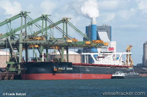
Find the position of the vessel Saham Max on the map. The latter are known coordinates and path.

marine traffic ship tracker show on live map

The current position of vessel Saham Max is -1.42167 lat / -43.1283 lng. Updated: 2024-05-06 22:29:18 UTC
Payload_mass:
400694 tonne
Gross tonnage:
201705
Service entry:
2013-01-01T00:00:00Z
Details:


Last coordinates of the vessel:
UTC, -1.585, -43.6583, course: -1, speed: 11
UTC, -1.49472, -43.4174, course: 80, speed: 11.7
UTC, -1.44167, -43.1883, course: -1, speed: 9
2024-05-06 22:29:18 UTC, -1.42167, -43.1283, course: -1, speed: 4


Most frequent ports a vessels calls at Saham Max (538004900):

Sao Luiz, traffic: 8
Sambu, traffic: 7
Singapore, traffic: 4
Selat Lombok, traffic: 3
Ponta da Madeira, traffic: 2
Tubarao, traffic: 1
Port Louis, traffic: 1

Link to the map:


Find another ship

Saham_Max (538004900) last ports (portcalls and passsages)

Ponta da Madeira | 2024-05-03 16:21:21
Singapore | 2024-03-25 20:32:17
Sambu | 2024-03-24 08:09:13
Ponta da Madeira | 2024-02-07 06:51:35
Sambu | 2023-12-18 17:31:58
Selat Lombok | 2023-11-21 12:17:15
Tubarao | 2023-10-18 04:30:56
Singapore | 2023-08-29 04:56:12
Sambu | 2023-08-29 04:12:48
Sao Luiz | 2023-06-25 00:31:56
Sao Luiz | 2023-02-20 18:09:30
Sao Luiz | 2023-02-16 15:09:10
Singapore | 2022-12-26 14:09:57
Port Louis | 2022-11-02 03:06:27
Sao Luiz | 2022-09-28 20:00:48
Singapore | 2022-08-17 16:51:07
Sambu | 2022-08-17 16:12:44
Sao Luiz | 2022-06-08 10:18:44
Sao Luiz | 2022-03-12 00:08:46
Sambu | 2022-01-15 17:00:35
Selat Lombok | 2021-12-12 08:08:17