 vesseltracker.com
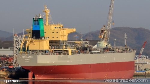
 Manolates
Current Status
Where is the vessel?
Manolates is currently in Near Barney Point, based on AIS data received about 3h ago.
Latest AIS update:
Current position: 23.85179° S, 151.31267° E (Near Barney Point)
Average speed (last 7 days): Loading…
Average speed (last 30 days): Loading…
Vessel profile: Manolates is a Oil Products Tanker with dimensions 181m x 32m.
This page combines live AIS, route history, probable destination signals, nearby traffic, and port activity for practical vessel monitoring.
The current position of vessel Manolates is -23.85179 lat / 151.31267 lng. Updated: 2026-03-25 15:34:36 UTCNearest reference points:
- Near Gladstone Harbor
- Near Boyne Island
- Near ROSSLYN
Currently sailing under the flag of Bahamas ![]()
Details:
Live Vessel Manolates Analytics (details, animations, etc.)
Recent AIS points (UTC):
2026-03-25 09:43:36 UTC · -23.85175, 151.31265 · SOG 0 kn · COG 81°2026-03-25 12:10:36 UTC · -23.85180, 151.31262 · SOG 0 kn · COG 81°
2026-03-25 14:22:36 UTC · -23.85182, 151.31268 · SOG 0 kn · COG 81°
2026-03-25 15:34:36 UTC · -23.85179, 151.31267 · SOG 0 kn · COG 81°