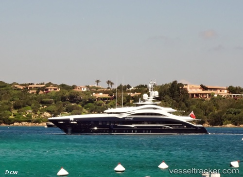
vessel SAIRU IMO: 1012737, Houseboat vesseltracker.com
Vessel SAIRU IMO: 1012737, Houseboat
MMSI: 378113654 callsign: ZJL2737 size: 50x9

Find the position of the vessel SAIRU on the map. The latter are known coordinates and path.

marine traffic ship tracker show on live map

The current position of vessel SAIRU is 44.03468 lat / 10.03941 lng. Updated: 2023-08-08 17:12:54 UTC

Currently sailing under the flag of Virgin Islands (U.K)

SAIRU built in 2015 year

Deadweight:
127 t

Details:


Last coordinates of the vessel:
2023-08-08 17:12:54 UTC, 44.03468, 10.03941, course: 205, speed: 0

Track of the vessel in the last 14 days


Most frequent ports a vessels calls at SAIRU (378113654):

Monaco, traffic: 4
Viareggio, traffic: 4
Villefranche, traffic: 4
Beaulieu-sur-Mer, traffic: 4
La Spezia, traffic: 4
Livorno, traffic: 2
Menton, traffic: 2
Nice, traffic: 2
Port-Vendres, traffic: 1
Antibes, traffic: 1
Golfe-Juan, traffic: 1
Cannes, traffic: 1
Port Vendres, traffic: 1

Link to the map:


Find another ship

SAIRU (378113654) last ports (portcalls and passsages)

La Spezia | 2023-04-09 19:27:46
La Spezia | 2023-04-05 19:04:32
La Spezia | 2023-04-01 17:04:19
Port Vendres | 2023-03-30 10:46:01
Golfe-Juan | 2022-02-10 17:56:35
Beaulieu-sur-Mer | 2022-02-10 09:11:46
Beaulieu-sur-Mer | 2022-02-10 06:15:52
Viareggio | 2022-01-18 18:50:36
Livorno | 2022-01-18 10:10:01
Viareggio | 2022-01-14 15:25:03