 vesseltracker.com
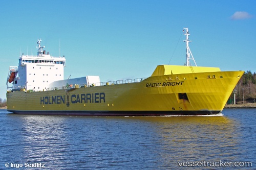
Vessel BALTIC BRIGHT IMO: 9129263, MMSI: 230042000 Ro-Ro Cargo Ship
UTC, 58.74136, 19.25258, course: 33, speed: 10.2
UTC, 59.02849, 19.59367, course: 34, speed: 9.7
2026-02-22 00:02:40 UTC, 59.57679, 20.14203, course: 322, speed: 9
Live AIS position:
UTC. 28 nm S of Föglö),
updated 2026-02-22 00:02:40 UTC.
Find the position of the vessel BALTIC BRIGHT on the map. The latter are known coordinates and path.
marine traffic ship tracker show on live map
The current position of vessel BALTIC BRIGHT is 59.57679 lat / 20.14203 lng. Updated: 2026-02-22 00:02:40 UTCCurrently sailing under the flag of Finland
BALTIC BRIGHT built in 1996 year
Deadweight:
6100 tDetails:
Last coordinates of the vessel:
UTC, 58.50729, 18.99932, course: 31, speed: 10UTC, 58.74136, 19.25258, course: 33, speed: 10.2
UTC, 59.02849, 19.59367, course: 34, speed: 9.7
2026-02-22 00:02:40 UTC, 59.57679, 20.14203, course: 322, speed: 9