 vesseltracker.com
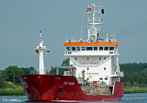
 Key Bora
Current Status
Where is the vessel?
Key Bora is currently in Near Oldervik, based on AIS data received about 3h ago.
Latest AIS update:
Current position: 69.73638° N, 19.74330° E (Near Oldervik)
Average speed (last 7 days): Loading…
Average speed (last 30 days): Loading…
Vessel profile: Key Bora is a Chemical Oil Products Tanker with dimensions 93m x 14m.
This page combines live AIS, route history, probable destination signals, nearby traffic, and port activity for practical vessel monitoring.
The current position of vessel Key Bora is 69.73638 lat / 19.74330 lng. Updated: 2026-03-25 15:48:59 UTCNearest reference points:
- Near Tromsø
- Near Tromso
- Near Skjervøy
Currently sailing under the flag of Gibraltar ![]()
Key Bora built in 2006 year
Deadweight:
3502 tDetails:
Live Vessel Key Bora Analytics (details, animations, etc.)
Recent AIS points (UTC):
2026-03-25 09:24:16 UTC · 69.60522, 19.81377 · SOG 0 kn · COG 116°2026-03-25 11:36:15 UTC · 69.60522, 19.81373 · SOG 0 kn · COG 116°
2026-03-25 14:09:16 UTC · 69.60521, 19.81373 · SOG 0 kn · COG 116°
2026-03-25 15:48:59 UTC · 69.73638, 19.74330 · SOG 11.7 kn · COG 9°