 vesseltracker.com
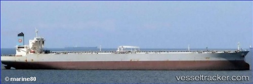
Vessel Pantanassa IMO: 9424261, MMSI: 249690000 Crude Oil Tanker
UTC, 25.03610, 56.69895, course: 335, speed: 5.6
UTC, 25.03610, 56.69895, course: 335, speed: 5.6
2026-03-24 00:35:01 UTC, 25.03610, 56.69895, course: 335, speed: 5.6
Live Vessel Pantanassa Analytics (details, animations, etc.)
Live AIS position: UTC. 13 nm S of Offshore Fujairah), updated 2026-03-24 00:35:01 UTC.Find the position of the vessel Pantanassa on the map. The latter are known coordinates and path.
marine traffic ship tracker show on live map
The current position of vessel Pantanassa is 25.03610 lat / 56.69895 lng. Updated: 2026-03-24 00:35:01 UTCNearest reference points:
- Near Fujairah
- Near Offshore Fujairah
- Near KHORFAKKAN
Currently sailing under the flag of Malta
Pantanassa built in 2011 year
Deadweight:
317800 tDetails:
Last coordinates of the vessel:
UTC, 24.87174, 56.74725, course: 340, speed: 10.5UTC, 25.03610, 56.69895, course: 335, speed: 5.6
UTC, 25.03610, 56.69895, course: 335, speed: 5.6
2026-03-24 00:35:01 UTC, 25.03610, 56.69895, course: 335, speed: 5.6