 vesseltracker.com
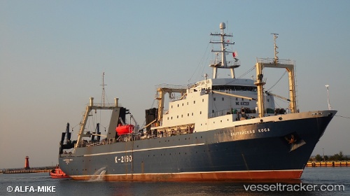
Vessel Baltiyskaya Kosa IMO: 8607268, MMSI: 273391650 Fishing Vessel
UTC, 61.65833, -5.14833, course: -1, speed: 3
UTC, 61.59167, -5.13833, course: -1, speed: 7
2026-03-23 00:02:08 UTC, 61.36137, -4.95266, course: 168, speed: 7.2
Live Vessel Baltiyskaya Kosa Analytics (details, animations, etc.)
Live AIS position: UTC. 50 nm SE of Thorshavn), updated 2026-03-23 00:02:08 UTC.Find the position of the vessel Baltiyskaya Kosa on the map. The latter are known coordinates and path.
marine traffic ship tracker show on live map
The current position of vessel Baltiyskaya Kosa is 61.36137 lat / -4.95266 lng. Updated: 2026-03-23 00:02:08 UTCCurrently sailing under the flag of Russia
Baltiyskaya Kosa built in 1989 year
Deadweight:
3372 tDetails:
Last coordinates of the vessel:
UTC, 61.62667, -4.98500, course: -1, speed: 3UTC, 61.65833, -5.14833, course: -1, speed: 3
UTC, 61.59167, -5.13833, course: -1, speed: 7
2026-03-23 00:02:08 UTC, 61.36137, -4.95266, course: 168, speed: 7.2