.
vessel RT FORCE IMO: 9556882, Tug vesseltracker.com
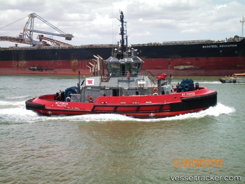
Vessel RT FORCE IMO: 9556882, MMSI: 311000967 Tug

callsign: C6EP9
size: 13x31

Live AIS position: UTC. Near Pointe Noire), updated 2026-02-22 00:15:45 UTC.

Find the position of the vessel RT FORCE on the map. The latter are known coordinates and path.

marine traffic ship tracker show on live map

The current position of vessel RT FORCE is -4.76628 lat / 11.83727 lng. Updated: 2026-02-22 00:15:45 UTC

Currently sailing under the flag of Bahamas

RT FORCE built in 2010 year

Deadweight:
0 t

Details:


Last coordinates of the vessel:
UTC, -4.78667, 11.83468, course: 93, speed: 0.1
UTC, -4.78667, 11.83465, course: 94, speed: 0
UTC, -4.76622, 11.83722, course: 199, speed: 0
2026-02-22 00:15:45 UTC, -4.76628, 11.83727, course: 202, speed: 0

Track of the vessel in the last 28 days


Most frequent ports a vessels calls at RT FORCE (311000967):

JURONG ISLAND, traffic: 7
BUKOM ISLAND, traffic: 2
PULAU SAMBU, traffic: 2
BATU AMPAR, traffic: 2
Sambu, traffic: 2
Torres Strait, traffic: 1
Thursday Island, traffic: 1
PENGERANG, traffic: 1
TANAH MERAH, traffic: 1
Port Moresby, traffic: 1
Singapore, traffic: 1

Link to the map:


Find another ship

RT_FORCE (311000967) last ports (portcalls and passsages)

BATU AMPAR | 2025-08-21 12:22:27
PULAU SAMBU | 2025-08-21 11:21:52
BUKOM ISLAND | 2025-08-21 02:33:53
JURONG ISLAND | 2025-08-19 08:18:46
JURONG ISLAND | 2025-08-15 08:05:19
JURONG ISLAND | 2025-08-11 06:41:33
JURONG ISLAND | 2025-08-07 05:49:40
JURONG ISLAND | 2025-07-02 02:56:37
JURONG ISLAND | 2025-06-28 02:22:44
BUKOM ISLAND | 2025-06-28 00:24:01
PULAU SAMBU | 2025-06-27 23:05:10
BATU AMPAR | 2025-06-27 22:10:23
TANAH MERAH | 2025-06-27 21:23:38
PENGERANG | 2025-06-27 18:46:38
Thursday Island | 2025-06-14 01:22:18
Port Moresby | 2025-06-09 22:40:27