 vesseltracker.com
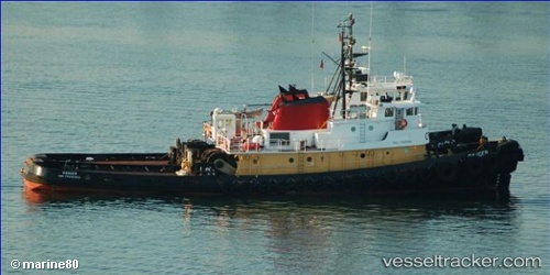
Ranger
Current StatusLive Vessel Ranger Analytics (details, animations, etc.)
Where is the vessel?
Ranger is currently in Near Blount Island, based on AIS data received about 986d ago.
Latest AIS update:
Current position: 30.41680° N, 81.53593° W (Near Blount Island)
Vessel profile: Ranger is a Tug with dimensions 10m x 40m.
This page combines live AIS, route history, probable destination signals, nearby traffic, and port activity for practical vessel monitoring.
The current position of vessel Ranger is 30.41680 lat / -81.53593 lng. Updated: 2023-07-12 13:07:18 UTCNearest reference points:
- Near Jacksonville
- Near Fernandina
- Near Ponte Vedra
Details:
Last coordinates of the vessel:
2023-07-12 13:07:18 UTC, 30.41680, -81.53593, course: 0, speed: 0