 vesseltracker.com
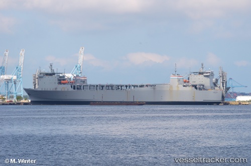
 Cape Rise
Current Status
Where is the vessel?
Cape Rise is currently in Near Norfolk, based on AIS data received about 2h ago.
Latest AIS update:
Current position: 36.85348° N, 76.31085° W (Near Norfolk)
Average speed (last 7 days): Loading…
Average speed (last 30 days): Loading…
Vessel profile: Cape Rise is a Ro Ro Cargo Ship with dimensions 198m x 30m.
This page combines live AIS, route history, probable destination signals, nearby traffic, and port activity for practical vessel monitoring.
The current position of vessel Cape Rise is 36.85348 lat / -76.31085 lng. Updated: 2026-03-25 07:55:53 UTCNearest reference points:
- Near Norfolk
- Near Sewell's Point
- Near Fentress
Currently sailing under the flag of USA ![]()
Cape Rise built in 1977 year
Deadweight:
22853 tDetails:
Live Vessel Cape Rise Analytics (details, animations, etc.)
Recent AIS points (UTC):
2026-03-25 01:49:54 UTC · 36.85347, -76.31084 · SOG 0 kn · COG 42°2026-03-25 04:16:51 UTC · 36.85345, -76.31082 · SOG 0 kn · COG 43°
2026-03-25 06:22:55 UTC · 36.85347, -76.31082 · SOG 0 kn · COG 42°
2026-03-25 07:55:53 UTC · 36.85348, -76.31085 · SOG 0 kn · COG 43°