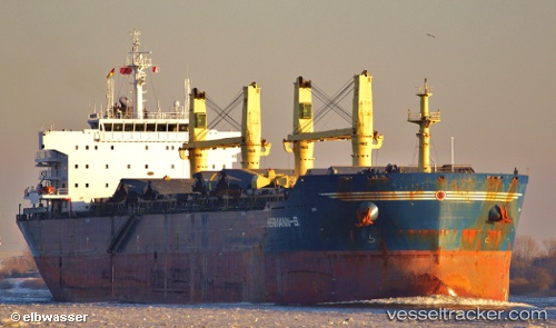
vessel 'CHEVAL BLANC' IMO: 9456123, vesseltracker.com
Vessel 'CHEVAL BLANC' IMO: 9456123,
MMSI: 538008600 callsign: size: x
Live AIS position: 38.94570° N, 117.76802° E UTC. Near Tianjin Pt), updated 2025-11-23 10:43:53 UTC.

Find the position of the vessel 'CHEVAL BLANC' on the map. The latter are known coordinates and path.

marine traffic ship tracker show on live map

The current position of vessel 'CHEVAL BLANC' is 38.94570 lat / 117.76802 lng. Updated: 2025-11-23 10:43:53 UTC
Details:


Last coordinates of the vessel:
UTC, 38.94570, 117.76799, course: 289, speed: 0
UTC, 38.94569, 117.76802, course: 289, speed: 0
UTC, 38.94570, 117.76803, course: 289, speed: 0
2025-11-23 10:43:53 UTC, 38.94570, 117.76802, course: 289, speed: 0

Track of the vessel in the last 14 days


Most frequent ports a vessels calls at 'CHEVAL BLANC' (538008600):

Sambu, traffic: 9
Dagu Bar, traffic: 9
Taku Bar, traffic: 8
Singapore, traffic: 6
Ta-Ku, traffic: 3
Dagu, traffic: 3
Dar Es Salaam, traffic: 2
Durban, traffic: 2
Mombasa, traffic: 2
Vishakhapatnam, traffic: 1
Yeosu, traffic: 1
Lianyungang, traffic: 1
Yosu, traffic: 1
Manila, traffic: 1
Richards Bay, traffic: 1

Link to the map:


Find another ship

'CHEVAL_BLANC' (538008600) last ports (portcalls and passsages)

Lianyungang | 2023-12-08 13:48:34
Ta-Ku | 2022-12-12 06:06:38
Dagu Bar | 2022-12-09 12:02:38
Yosu | 2022-11-23 11:06:06
Manila | 2022-09-26 04:37:20
Singapore | 2022-06-08 22:52:34
Singapore | 2022-06-04 22:47:32
Sambu | 2022-06-04 22:30:10
Vishakhapatnam | 2022-05-27 04:14:18
Trincomalee | 2022-05-17 10:11:57
Richards Bay | 2022-04-18 21:34:40
Durban | 2022-03-09 21:51:50
Mombasa | 2022-02-20 21:15:01
Dar Es Salaam | 2022-02-12 00:37:26
Singapore | 2022-01-17 13:35:08
Singapore | 2022-01-17 13:20:19
Sambu | 2022-01-17 13:15:09
Sambu | 2022-01-17 13:05:50
Taku Bar | 2022-01-06 14:51:12
Taku Bar | 2022-01-06 14:40:41
Dagu Bar | 2022-01-06 13:36:01
Ta-Ku | 2021-12-22 08:58:54
Dagu Bar | 2021-12-22 08:01:23
Taku Bar | 2021-12-22 07:41:33
Taku Bar | 2021-12-14 02:36:59