 vesseltracker.com
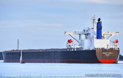
Vessel STAR VESTA IMO: 9446506, MMSI: 538010999 Bulk Carrier
UTC, -26.24010, 48.95327, course: 243, speed: 11.5
UTC, -26.41628, 48.58922, course: 243, speed: 10.9
2026-03-25 03:36:37 UTC, -26.58993, 48.23455, course: 241, speed: 11.6
Live Vessel STAR VESTA Analytics (details, animations, etc.)
Live AIS position: UTC. 115 nm SE of Ehoala), updated 2026-03-25 03:36:37 UTC.Find the position of the vessel STAR VESTA on the map. The latter are known coordinates and path.
marine traffic ship tracker show on live map
The current position of vessel STAR VESTA is -26.58993 lat / 48.23455 lng. Updated: 2026-03-25 03:36:37 UTCCurrently sailing under the flag of Marshall Islands
Details:
Last coordinates of the vessel:
UTC, -26.09085, 49.26077, course: 241, speed: 11.3UTC, -26.24010, 48.95327, course: 243, speed: 11.5
UTC, -26.41628, 48.58922, course: 243, speed: 10.9
2026-03-25 03:36:37 UTC, -26.58993, 48.23455, course: 241, speed: 11.6