 vesseltracker.com
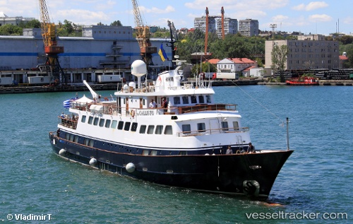
Vessel TO CALLISTO IMO: 5416553, MMSI: 341166001 Passengers Ship
UTC, 37.96046, 23.57565, course: -1, speed: 0
UTC, 37.96047, 23.57567, course: -1, speed: 0
2026-03-24 23:31:19 UTC, 37.96048, 23.57568, course: -1, speed: 0
Live Vessel TO CALLISTO Analytics (details, animations, etc.)
Live AIS position: UTC. Near PERAMA), updated 2026-03-24 23:31:19 UTC.Find the position of the vessel TO CALLISTO on the map. The latter are known coordinates and path.
marine traffic ship tracker show on live map
The current position of vessel TO CALLISTO is 37.96048 lat / 23.57568 lng. Updated: 2026-03-24 23:31:19 UTCCurrently sailing under the flag of Saint Kitts and Nevis
Details:
Last coordinates of the vessel:
UTC, 37.96046, 23.57567, course: -1, speed: 0UTC, 37.96046, 23.57565, course: -1, speed: 0
UTC, 37.96047, 23.57567, course: -1, speed: 0
2026-03-24 23:31:19 UTC, 37.96048, 23.57568, course: -1, speed: 0