 vesseltracker.com
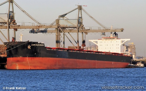
 Cape Alexandros
Current Status
Where is the vessel?
Cape Alexandros is currently in 100 nm W of Makassar, based on AIS data received about 1h ago.
Latest AIS update:
Current position: 4.52641° S, 117.84489° E (100 nm W of Makassar)
Average speed (last 7 days): Loading…
Average speed (last 30 days): Loading…
Vessel profile: Cape Alexandros is a Bulk Carrier with dimensions 292m x 45m.
This page combines live AIS, route history, probable destination signals, nearby traffic, and port activity for practical vessel monitoring.
The current position of vessel Cape Alexandros is -4.52641 lat / 117.84489 lng. Updated: 2026-03-25 17:21:22 UTCNearest reference points:
- 117 nm W of Panakukang
- 12 nm W of Panakukang
- Near Panakukang
Currently sailing under the flag of Liberia ![]()
Cape Alexandros built in 2010 year
Deadweight:
179166 tDetails:
Live Vessel Cape Alexandros Analytics (details, animations, etc.)
Recent AIS points (UTC):
2026-03-25 12:08:59 UTC · -5.29527, 117.27980 · SOG 10.5 kn · COG 37°2026-03-25 13:54:31 UTC · -5.04899, 117.46241 · SOG 10.6 kn · COG -1°
2026-03-25 15:24:18 UTC · -4.82242, 117.62577 · SOG 11.5 kn · COG 35°
2026-03-25 17:21:22 UTC · -4.52641, 117.84489 · SOG 11 kn · COG 34°