 vesseltracker.com
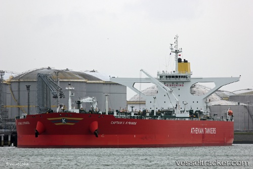
Vessel CAPTAIN X KYRIAKOU IMO: 9602928, MMSI: 636020559 Crude Oil Tanker
UTC, 27.24852, 50.37694, course: 12, speed: 0.2
UTC, 27.24852, 50.37729, course: 7, speed: 0.1
2026-03-01 10:15:09 UTC, 27.24860, 50.37713, course: -1, speed: 0.2
Live AIS position:
UTC. 38 nm E of AL JUBAIL),
updated 2026-03-01 10:15:09 UTC.
Find the position of the vessel CAPTAIN X KYRIAKOU on the map. The latter are known coordinates and path.
marine traffic ship tracker show on live map
The current position of vessel CAPTAIN X KYRIAKOU is 27.24860 lat / 50.37713 lng. Updated: 2026-03-01 10:15:09 UTCCurrently sailing under the flag of Liberia
CAPTAIN X KYRIAKOU built in 2013 year
Deadweight:
299991 tDetails:
Last coordinates of the vessel:
UTC, 27.24021, 50.38114, course: 13, speed: 3.2UTC, 27.24852, 50.37694, course: 12, speed: 0.2
UTC, 27.24852, 50.37729, course: 7, speed: 0.1
2026-03-01 10:15:09 UTC, 27.24860, 50.37713, course: -1, speed: 0.2