 vesseltracker.com
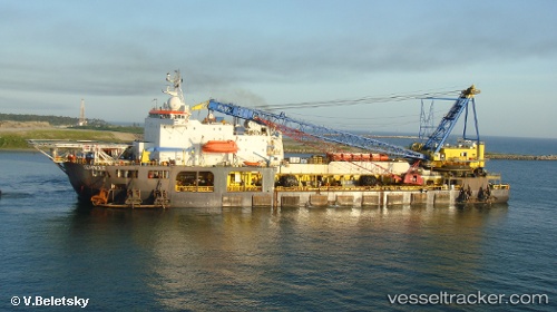
Vessel Seminole IMO: 7645550, MMSI: 247274900 Pipe Layer
UTC, 5.56701, 0.07879, course: 160, speed: 0.1
UTC, 5.56670, 0.07841, course: 137, speed: 0.1
2026-03-21 19:47:32 UTC, 5.56677, 0.07839, course: 146, speed: 0.1
Live Vessel Seminole Analytics (details, animations, etc.)
Live AIS position: UTC. Near Tema), updated 2026-03-21 19:47:32 UTC.Find the position of the vessel Seminole on the map. The latter are known coordinates and path.
marine traffic ship tracker show on live map
The current position of vessel Seminole is 5.56677 lat / 0.07839 lng. Updated: 2026-03-21 19:47:32 UTCCurrently sailing under the flag of Italy
Seminole built in 1975 year
Deadweight:
10969 tDetails:
Last coordinates of the vessel:
UTC, 5.56699, 0.07886, course: 155, speed: 0.1UTC, 5.56701, 0.07879, course: 160, speed: 0.1
UTC, 5.56670, 0.07841, course: 137, speed: 0.1
2026-03-21 19:47:32 UTC, 5.56677, 0.07839, course: 146, speed: 0.1