 vesseltracker.com
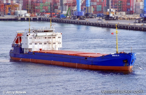
Vessel Mriya S IMO: 8858673, MMSI: 273216170 General Cargo Ship
UTC, 45.24473, 36.52271, course: 231, speed: 21.1
UTC, 45.24473, 36.52271, course: 231, speed: 21.1
2026-02-24 05:59:29 UTC, 45.24473, 36.52271, course: 231, speed: 21.1
Live AIS position:
UTC. Near KOMYSH BURUNSKA),
updated 2026-02-24 05:59:29 UTC.
Find the position of the vessel Mriya S on the map. The latter are known coordinates and path.
marine traffic ship tracker show on live map
The current position of vessel Mriya S is 45.24473 lat / 36.52271 lng. Updated: 2026-02-24 05:59:29 UTCCurrently sailing under the flag of St Vincent Grenadines
Mriya S built in 1992 year
Deadweight:
3983 tDetails:
Last coordinates of the vessel:
UTC, 45.05965, 36.60063, course: 228, speed: 14UTC, 45.24473, 36.52271, course: 231, speed: 21.1
UTC, 45.24473, 36.52271, course: 231, speed: 21.1
2026-02-24 05:59:29 UTC, 45.24473, 36.52271, course: 231, speed: 21.1