 vesseltracker.com
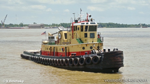
Vessel G. Shelby Friedrichs IMO: 8992534, MMSI: 366983270 Tug
UTC, 30.19808, -91.11920, course: -1, speed: 0.1
UTC, 30.19807, -91.11922, course: -1, speed: 0
2026-03-24 17:57:39 UTC, 30.19807, -91.11920, course: -1, speed: 0.1
Live Vessel G. Shelby Friedrichs Analytics (details, animations, etc.)
Live AIS position: UTC. Near White Castle), updated 2026-03-24 17:57:39 UTC.Find the position of the vessel G. Shelby Friedrichs on the map. The latter are known coordinates and path.
marine traffic ship tracker show on live map
The current position of vessel G. Shelby Friedrichs is 30.19807 lat / -91.11920 lng. Updated: 2026-03-24 17:57:39 UTCCurrently sailing under the flag of USA
G. Shelby Friedrichs built in 1959 year
Details:
Last coordinates of the vessel:
UTC, 30.19806, -91.11922, course: -1, speed: 0.1UTC, 30.19808, -91.11920, course: -1, speed: 0.1
UTC, 30.19807, -91.11922, course: -1, speed: 0
2026-03-24 17:57:39 UTC, 30.19807, -91.11920, course: -1, speed: 0.1