 vesseltracker.com
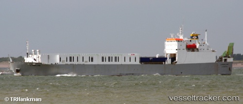
Vessel DALKA IMO: 9007764, MMSI: 725003291 Ro-Ro Cargo Ship
UTC, -41.52001, -73.03721, course: 145, speed: 0
UTC, -41.52004, -73.03721, course: 144, speed: 0
2026-02-26 11:28:45 UTC, -41.52004, -73.03722, course: 144, speed: 0
Live AIS position:
UTC. Near Puerto Montt),
updated 2026-02-26 11:28:45 UTC.
Find the position of the vessel DALKA on the map. The latter are known coordinates and path.
marine traffic ship tracker show on live map
The current position of vessel DALKA is -41.52004 lat / -73.03722 lng. Updated: 2026-02-26 11:28:45 UTCCurrently sailing under the flag of Chile
DALKA built in 1992 year
Deadweight:
7000 tDetails:
Last coordinates of the vessel:
UTC, -41.52005, -73.03717, course: 145, speed: 0UTC, -41.52001, -73.03721, course: 145, speed: 0
UTC, -41.52004, -73.03721, course: 144, speed: 0
2026-02-26 11:28:45 UTC, -41.52004, -73.03722, course: 144, speed: 0