 vesseltracker.com
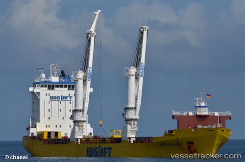
Vessel Happy Ranger IMO: 9139311, MMSI: 245539000 General Cargo Ship
UTC, 44.45921, 12.25068, course: 200, speed: 0
UTC, 44.45923, 12.25068, course: 200, speed: 0
2026-02-10 09:57:49 UTC, 44.45924, 12.25063, course: 200, speed: 0
Live AIS position:
UTC. Near Marina di Ravenna),
updated 2026-02-10 09:57:49 UTC.
Find the position of the vessel Happy Ranger on the map. The latter are known coordinates and path.
marine traffic ship tracker show on live map
The current position of vessel Happy Ranger is 44.45924 lat / 12.25063 lng. Updated: 2026-02-10 09:57:49 UTCCurrently sailing under the flag of Netherlands
Happy Ranger built in 1998 year
Deadweight:
12950 tDetails:
Last coordinates of the vessel:
UTC, 44.45922, 12.25066, course: 200, speed: 0UTC, 44.45921, 12.25068, course: 200, speed: 0
UTC, 44.45923, 12.25068, course: 200, speed: 0
2026-02-10 09:57:49 UTC, 44.45924, 12.25063, course: 200, speed: 0